
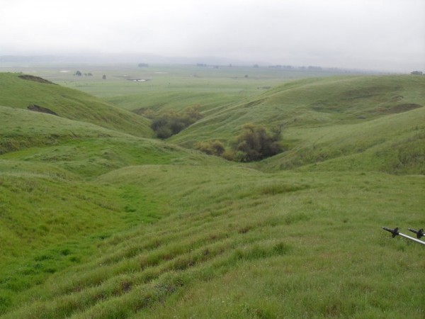
If you were to start hiking on the north side of Sonoma Mountain in Santa Rosa and keep heading south, you would eventually hit San Pablo Bay. It would take awhile and you would have to go through a patchwork of public and private lands, but that’s an impressive greenway across a swatch of Sonoma County. It ends at a 2,300-plus-acre parcel of land now owned by the Sonoma Land Trust. That would be Sears Point, which you’ve passed if you’ve driven south on Highway 116 and then headed east on Highway 37 toward Napa or Vallejo.
The land is a mix of wetlands and grassy hills, covered with cows, wildflowers and opportunities for views in all directions. And that’s where I was hiking the other night, for a rare weekday sunset hike, guided by very knowledgeable experts who explained both the botany and anthropology of the terrain. It’s helpful to know that the San Pablo Bay used to be much farther inland, and only the development in the last two centuries of levees and tidal sloughs for the purposes of ranching and commercial boating pushed the bay back to its present location.
Those 1,000 acres of wetlands are pretty ecologically important. If you’ve paid attention to why Hurricane Katrina was such a disaster, you probably already understand that nutrient-rich wetlands suck up lots of carbon, keep incoming water at bay and are vital to sustainable development. So the conservation of Sears Point is about more than providing scenic views.
The land came into public ownership – and avoided becoming home to a nbso online casino reviews – about seven years ago when the Land Trust purchased it for $20 million, including nearly $2 million from 600 individual donors. The area now houses the San Pablo Bay office of the U.S. Fish and Wildlife Service, the future home of the Land Trust’s Baylands Center, and the remains of an old dairy ranch. It also has literally dozens of different wildflower species and grasses, only some of which were visible on the wet, cloud-covered hike. I did count at least eight different types, but there were far more.
There isn’t much of an elevation gain as you head north from Highway 37 into the green hills nor are there any trails, other than cattle paths, so it’s a bit of off-road hiking at its most relaxed state. Nearing the top, you’re close to the edge of the Infineon Raceway property, but more importantly, there’s a terrific view of the bay itself and to the west, some of Petaluma.
Our hike, a large loop, covered about five miles in an intermittent drizzle. The area is as much about what is there as what will be. The combination of county parks, state agencies and area nonprofits envision connections – where Tolay Lake Regional Park may continue south, and where the existing Bay Trail along San Pablo Bay may become much longer than a spur and wind across the northern edge of the waterway. Where there are valleys in the Sears Point hills there may someday be groves of willow trees and habitat ponds for endangered frogs. That’s just a sample of what’s to come around there. For now, it’s lush landscape and expansive wetlands to serve as pleasant scenery as you drive by.
[nggallery id=48]
 , New York native, I spent half of my life hibernating indoors, but for the past five years I have basked in the thrilling opportunity to enjoy year round hiking on the many trails of beautiful Northern California. In this blog I will continue in the tradition of trailhead, to recap the hikes I have taken and share the insights of my fellow hikers. Along with day hikes, I am also interested in dog friendly trails, and backpacking trips as well. Please feel free to offer suggestions of where I should hike next, or share tales of where you have explored. . Guest blog entries are extremely welcome as are your photos from your own hikes.