
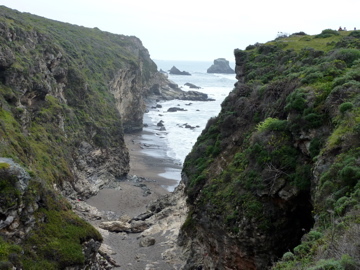
There was a moment last weekend when a few of us were down on the Pacific Ocean at the base of a large cliff. The water had rushed out allowing us time to dash further along the edge of the cliff into a small cave-like recess. But suddenly the water came in, not really trapping us but momentarily providing a shock as we realized just how quickly the area where we were could be underwater and unreachable.
Hiking provides a lot of these kinds of moments. One minute you’re walking along a trail and sweating under a blazing sun and shedding layers, and then down a valley you go and you’re in a shaded cool grove that seems to be another land entirely.
Over the past three weeks, I’ve explored different parts of the Point Reyes National Seashore, each time being awed and pleased by the diversity of the landscape, the ruggedness of the terrain, and the overall power of the ocean. There’s no better place to see what water can shape than the rocky walls of Sculptured Beach.
That was one of our two destinations last weekend on what turned out to be a strenuous, but enjoyably so, 14-plus mile jaunt that started at the Bear Valley Visitor Center at Point Reyes. From the visitor center, our first move was to head the nearly two miles straight up to the peak of Mount Wittenberg. The climb offers little recourse for breathers except to keep moving, but at the top was a terrific view of the area and enough of the ocean to motivate hikers to keep moving. For me, it was even more difficult than I expected. A few hours earlier, I had taken a cross-country flight back into SFO and had the misfortune of a middle seat and no sleep for the trip. Part of me thought going home and going to bed was the right move, but I bit the bullet and decided a vigorous outdoor hike was an even better move. After some initial pains, it was worth getting out and jettisoning the jet lag.
From Mount Wittenberg, we headed over to the coast, stopping first at Sculptured Beach. It’s so named because the water has literally sculpted the rocky coast with striations visible along the shoreline. The rocks themselves are great for picnicking, climbing and just lounging about. I had been to that beach once before on a different hike but then headed back up to Limantour Beach, which is to the north. This time, after a lunch break at the beach, we took the Coast Trail 3.5 miles to the south with the goal of reaching Arch Rock. On a prior hike, I had been passed by a group of hikers who said they were heading there, which made me curious.
Well, it was well worth the rigorous walk to get there. The rock is a steep overlook atop a cliff formation, and is a perfect hanging-out spot. In fact, the group we stumbled across was having quite a picnic, complete with bacon in a frying pan. Is there anything better than the smell of bacon after walking 10 miles? I wouldn’t have predicted that I’d be so taken by it, but I was.
In any event, from Arch Rock, a few of us scrambled down a path and then across a creek to the aforementioned idyllic oceanside cave spot. Not an easy scamper but very cool.
From Arch Rock back to the visitor center was about four miles to complete the loop. I keep going back to Point Reyes and each time the experience is a new one, from the sights on the trail, to the way the terrain treats me, to the encounters with other hikers. It’s only early spring and the weather is still sporting a stiff breeze along the ocean, but when in a few months, it’ll be hard to top a weekend day on the coast.
 , New York native, I spent half of my life hibernating indoors, but for the past five years I have basked in the thrilling opportunity to enjoy year round hiking on the many trails of beautiful Northern California. In this blog I will continue in the tradition of trailhead, to recap the hikes I have taken and share the insights of my fellow hikers. Along with day hikes, I am also interested in dog friendly trails, and backpacking trips as well. Please feel free to offer suggestions of where I should hike next, or share tales of where you have explored. . Guest blog entries are extremely welcome as are your photos from your own hikes.