
 Like the mailman, I was going to be outside this weekend, no matter the elements. After surviving a dental emergency last week along with some pressing work issues, my head was in need of fresh air by the time Saturday rolled around. The one downside was that this pesky storm system was expected to arrive in the North Bay right about then and be a continuous downpour for the next week. I’ve hiked in rain, both torrential and mild, so that’s not much of a deterrent. And it was cloudy, but dry, Saturday morning when I arrived at the trailhead leading into Cataract Falls.
It’s in west Marin County, several miles past Fairfax along an extremely winding road that curves around Alpine Lake and eventually heads to the coast. You can keep going from some of the trails here and easily hop over to Mount Tamalpais, and then over to the ocean. Probably a great hike for a different day.
The falls are on land owned by the Marin Municipal Water District, which doesn’t sound all that appealing, but it is actually quite a gem, encompassing about 130 miles of hiking trails in the Mount Tam watershed region. Our group explored a literal patchwork of trails that climb up and around the namesake falls, and then through a few different terrains as well. Just to the main falls itself is about 2 and a half miles and a climb of about 1,000 feet. For our hiking group, we did a bit more, heading out on some adjacent trails to add approximately 5 more miles to the hike. In parts, the elevation was steep quickly – we climbed about 2,400 feet in our entire hike of going up and down a few sections – and there are some funky bridges and stairs to navigate. Given that the rain hadn’t started, the ground was fine, although by the last hour, a slight drizzle had started, making for some slippery conditions and muddy boots to contend with.
While this isn’t the longest hike around, it’s a challenging one. Hiking into the falls requires a fair amount of climbing, and then looping from Laurel Dell around and by the Alpine Lake Reservoir is not a flat-terrain kind of route by any measure. There’s plenty to see along the way, including some amazing wildflowers and an impromptu music camp, complete with wind chimes and other instruments, that has to be seen to be believed.
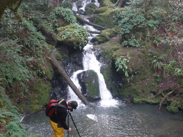
On several points, I felt as if I were in a tropical rainforest, as you keep going up and around and seeing even more waterfalls. There are at least seven or eight different cascading falls to be seen along what is called Cataract Creek. Waterfall hikes can be exhilirating, and while I’ve been to Yosemite and Niagara Falls, there’s plenty of other opportunities. I wasn’t aware of this one so close to home, but now that I have, I suspect I’ll go back and try a few more of the trails, if only to have an easy excuse to get wet again. I had been warned that in the summertime, there’s not much to see. Given the rainy season of late, all the falls were in top form, giving us some spectacular views with the water rushing downstream through the redwoods.
P.S. I was going to add a note into this blog post about why it’s named Cataract Falls. If you know why, feel free to comment below.
[nggallery id=9]
 , New York native, I spent half of my life hibernating indoors, but for the past five years I have basked in the thrilling opportunity to enjoy year round hiking on the many trails of beautiful Northern California. In this blog I will continue in the tradition of trailhead, to recap the hikes I have taken and share the insights of my fellow hikers. Along with day hikes, I am also interested in dog friendly trails, and backpacking trips as well. Please feel free to offer suggestions of where I should hike next, or share tales of where you have explored. . Guest blog entries are extremely welcome as are your photos from your own hikes.