
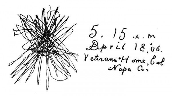
Seismoscope image from Yountville. 1906 earthquake. (Press Democrat file)
Earthquake Trail, Point Reyes National Seashore
When I decided to move to California, more than one person commented that
I should watch out for earthquakes. Um, would I see them coming and run out of the way? Having lived in two different tornado-alley states for awhile and in three different hurricane-prone coastal states too (hey, I get around…..), I have a lot of respect for power of natural disasters. But with both tornados and hurricanes, they generally don’t come by surprise. My slim, and possibly shakily-based, understanding of earthquakes was that little ones happen all the time and nobody feels them, medium ones happen occasionally and cause some shaking in a few places, big ones happen every few decades and cause massive destruction, and The Big One has yet to happen.On a future hike, I hope to check out Crystal Springs, which is in the Santa Cruz Mountains and is in a valley created by the San Andreas Fault. Much farther north is the “Earthquake Trail.” It’s a small trail, but it’s got a big story behind it so I had to check it out when I happened by it on a recent weekend outing. The so-called Earthquake Trail traces part of the San Andreas Fault. It’s at Point Reyes National Seashore near the Bear Valley Visitor Center and is about a half-mile loop near the parking/grill area.
The 1906 quake shifted Point Reyes to the northwest by about 20 feet, and the trail winds its way along the trace line. At one point, there’s a fence split in two parts and the sign explains that half of this fence “jumped” 18 feet when the quake hit. There are a few interpretive signs and pictures along the trail explaining everything from the geology of tectonic plates to the impact of the quake on area communities. It’s an easy loop, and the two kids with me enjoyed it too. Part of the fun of hiking – especially as a California newcomer – is learning about this area in all sorts of detail. Prior to my trail walk, I didn’t know that the fault line stretches 800 miles or that the fault is slipping at about 2 inches a year, meaning in about a million years, we’ll have some big problems. I did know that the 1989 quake halted Game 3 of the Bay Area World Series because I’m a sports trivia geek.
-
Earthquake Trail, Point Reyes National Seashore When I decided to move to California, more than one person commented that I should watch out for..." href='https://trailhead.blogs.pressdemocrat.com/10244/quaking-in-my-hiking-boots/yountseismo2jpg/'>
- Seismoscope image from Yountville. 1906 earthquake. (Press Democrat file)
-
Earthquake Trail, Point Reyes National Seashore When I decided to move to California, more than one person commented that I should watch out for..." href='https://trailhead.blogs.pressdemocrat.com/10244/quaking-in-my-hiking-boots/86282057_f32097d741_ojpg/'>
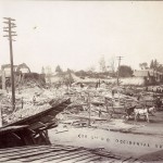
- 4/13/2006: 5TH AND B STREETS, SANTA ROSA: Horses haul rubble not far from where Harold Bruner felt the earthquake.
-
Earthquake Trail, Point Reyes National Seashore When I decided to move to California, more than one person commented that I should watch out for..." href='https://trailhead.blogs.pressdemocrat.com/10244/quaking-in-my-hiking-boots/fortross/'>
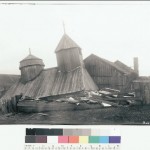
- 4/13/2006: Fort Ross, Sonoma County: The chapel built in 1825 came crashing down, though the roof remained intact. (Press Democrat file)
 , New York native, I spent half of my life hibernating indoors, but for the past five years I have basked in the thrilling opportunity to enjoy year round hiking on the many trails of beautiful Northern California. In this blog I will continue in the tradition of trailhead, to recap the hikes I have taken and share the insights of my fellow hikers. Along with day hikes, I am also interested in dog friendly trails, and backpacking trips as well. Please feel free to offer suggestions of where I should hike next, or share tales of where you have explored. . Guest blog entries are extremely welcome as are your photos from your own hikes.